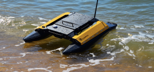
 Based on the proven technology of aerial drones we developed a system of self-bathymetric survey that is unique in Italy. This technique involves the use of a small electric powered boat which is able, in a completely autonomous way, to “map” the bottom of lakes, rivers and harbors generating a three dimensional image of the conformation below the water surface.

The data obtained will allow planners, geologists and other professionals to obtain a clear assessment of the state of the seabed with the aim to plan with greater precision and efficiency needed interventions.

The system is controlled by an artificial intelligence system that processes the information coming from satellites and intergrates them with the inertial sensors installed on board. Such processing capability makes it possible to do autonomous navigation and consequently to obtain an increase in accuracy and a sensitive reduction in the time of investigation. The operator, via a laptop computer determines the area of interest and traces the contours on a virtual map. The software then generates a grid of inspection on the basis of the data requested by the customer and sends the route to the boat that will perform the inspection sending real-time collected data and saving it on internal memory.